I use gps info of my cell phone when I take pictures, so that I can find where these pics were taken after a long voyage. I also wish to export these pics to google earth or google map, which can be kml or kmz. https://geosetter.de/en/download-en/ Geo setter is a very powerful one. Some times my phone was not able to add geotag info on the the picture, since it does not have location info at that time(indoor picture or gps was not available). Of course you can edit the pic, but geo sitter provide a better interface, you can pic a location on map and then assign the location to the photo that you selected. much easier than deal with coordinates. I notes the steps as following. After install geosetter, select the folder where you store your images. photos with a blue location dot means these pics contain geotag. select one pic with no blue dot, and go to top menu "map", select "show overview map" a google map will show up with goe location of pictures...
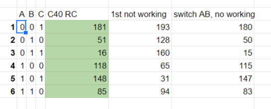
The HALL sensors provide an indication as to where in the electrical revolution the rotor is. You get enough information to run the motor in BLDC mode depending on the HALL signal values. In BLDC mode there are six phases and the hall sensors conspire to make exactly six combinations. When driving the motor in FOC mode, the position of the rotor during an electrical revolution is thought of as a position on a compass: say 0-360 degrees. Now the three hall signals combine to make a 3-bit number 0-7. So now for each possible combination you note the average compass value when that value is output by the hall sensors. So if during 0-60 the combination 001 or "1" shows on the hall sensors, you put the average "30" in the table at position 1. Now 60-120 teh hall sensors show 011, so you put the average 90 in position 3 in the table. Now Benjamin decided to save a few bits by instead of counting the revolution in human-convention-units of a degree (i.e. ...
I wish to add GPS on my running meshtastic client on TTGO lora32. I have a GPS module outputs with nema at 9600bps. In the config app, in the position sector, you can find the redefine of PGS pins. I firstly use IO00 as GPS_RX_pin. But it does not work. I guess the web config use 0 as none-config default. Then I want to know what is the default pin for GPS in meshtastic for TTGO Lora 32, I use the 2.4.x firmware for V2.1-1.6. Checked the git, there is no default gps pin for this hardware, so I changed the gps to mcu pin to 34, leave other pins stuff as 0 and do the config . And it works. there is a new flasher, which still has LILYGO T-Lora V2.1-1.6 as board selection, with latest 2.5.xx firmware maintain 34,0,0 setting is no longer working. after few try, I decided to set to 34/32/25, where 32/25 are free pin on my board. I also reference to LILYGO Meshtastic T-Beam V1.2 ESP32 LoRaGPS WiFi , it has a gps on 34/12 with 34/12/0 the setting is still working


留言
張貼留言