MAVproxy on windows with real pixhawk
Before Going on to beaglebone, I wish to test the following:
1. connect a pixhawk telemetry 2 through a FTDI uart to usb to my windows PC.
2. run a MAVproxy on wondows
3. connect mission planner(on local PC) to pixhawk through MAVproxy
4. same as 3, but from another PC in the same network.
I have done this with dronekit-sitl on PC, according to the dronekit-sitl paper, connect 2 link to it can cause unstable. For multiple connections, it recommands MAVproxy.
When I first started, I have install MAVproxy through windows installer, as well as pip through command line.(I also use python on PC)
double installation cause the program to run very strangely, so I uninstall MAVproxy from windows uninstaller, and pip uninstall mavproxy through command line. Then run again the windows installer again from this page:
http://ardupilot.github.io/MAVProxy/html/getting_started/index.html
MAVproxy starts to show correct information....but I still can't get local or remote GCS connected.
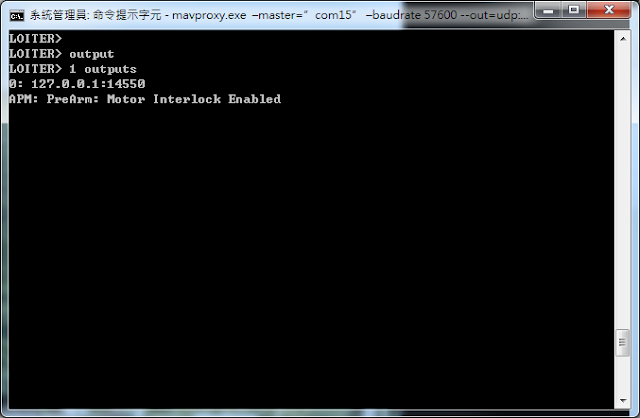
Then I found out that there is a command "output", in MAVproxy, type in, it will response on the output Nr and output UDP port.
I found out that the problem is on my command option....I did not get any output with my previous command.
So, the make a MAVproxy with local UDP at 14550 the command will be :

and after start, we can add link or add output:
ex:add an udp output for a GCS on IP192.168.2.108 and use udp 14550
output add 192.168.2.108:14550
IP address can be different
output add 192.168.0.13:14550

this are the correct options allow me to connect 2 GCS from 2 different PC.
so for every additional PC with GCS you will need more IP specified out put.
if you want to boradcast, you can do :
output add 192.168.0.255:14550
where the 192.168.0.xxx is the setting of your router network.
so for broadcasting
mavproxy.exe --master="com105" --baudrate=115200 --out=udp:192.168.0.255:14550
1. connect a pixhawk telemetry 2 through a FTDI uart to usb to my windows PC.
2. run a MAVproxy on wondows
3. connect mission planner(on local PC) to pixhawk through MAVproxy
4. same as 3, but from another PC in the same network.
I have done this with dronekit-sitl on PC, according to the dronekit-sitl paper, connect 2 link to it can cause unstable. For multiple connections, it recommands MAVproxy.
When I first started, I have install MAVproxy through windows installer, as well as pip through command line.(I also use python on PC)
double installation cause the program to run very strangely, so I uninstall MAVproxy from windows uninstaller, and pip uninstall mavproxy through command line. Then run again the windows installer again from this page:
http://ardupilot.github.io/MAVProxy/html/getting_started/index.html
MAVproxy starts to show correct information....but I still can't get local or remote GCS connected.
Then I found out that there is a command "output", in MAVproxy, type in, it will response on the output Nr and output UDP port.

I found out that the problem is on my command option....I did not get any output with my previous command.
So, the make a MAVproxy with local UDP at 14550 the command will be :

and after start, we can add link or add output:
ex:add an udp output for a GCS on IP192.168.2.108 and use udp 14550
output add 192.168.2.108:14550
IP address can be different
output add 192.168.0.13:14550

this are the correct options allow me to connect 2 GCS from 2 different PC.
so for every additional PC with GCS you will need more IP specified out put.
if you want to boradcast, you can do :
output add 192.168.0.255:14550
where the 192.168.0.xxx is the setting of your router network.
so for broadcasting
mavproxy.exe --master="com105" --baudrate=115200 --out=udp:192.168.0.255:14550


留言
張貼留言